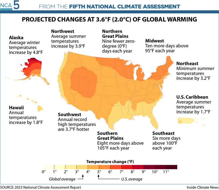
If there is one overarching message from the nation’s latest climate assessment, it is that nowhere will be spared.
Hotter temperatures are coming to every corner of the country, as are weather extremes. Many regions are experiencing more frequent, heavier rains, while others are seeing worsening drought. Some are getting both. Everywhere, these changes are translating into greater stresses on Americans’ health through worsening heatwaves, wildfires, hurricanes, floods and the psychological toll of mounting disasters.
“There is not a part of the U.S. that gets a pass on climate impacts,” one Biden administration official said during a briefing for reporters on the Fifth National Climate Assessment, or NCA. The sprawling, peer-reviewed federal report, released Tuesday, is mandated by Congress and provides the most comprehensive look at the state of climate change across the country.
How those impacts show themselves will vary greatly, with each region suffering its own particular plagues. For extreme precipitation and the floods it unleashes, the official said, the Northeast has some of the worst. In the Southeast, where hotter temperatures marry with stifling humidity, residents and those working outside are struggling with some of the nation’s worst extreme heat. Out West, wildfires and drought are poisoning the air and parching fields and taps. Across the Midwest, floods, droughts and extreme heat are disrupting farmers’ livelihoods and traditions. Along the coasts, high-tide flooding is worsening almost universally as rising seas inundate neighborhoods.

The assessment highlights that these impacts are falling disproportionately on less wealthy communities and Black and Indigenous Americans and people of color. In the Southeast, for example, the report says that “the institutions of slavery and intergenerational ownership of individuals as property” have meant that Black people and other people of color “are disproportionately exposed to environmental risks and with fewer resources to address them when compared to majority White communities.” Other regions, the report says, have their own inequities.
States in all regions have begun efforts to cut their climate pollution and adapt to the impacts of climate change, according to the assessment, with the greatest number of actions coming in the Northeast and Southwest, a region that includes California.
On Tuesday, the Biden administration accompanied the report with an announcement of $6 billion in funding to help those efforts. The nation’s electric grid will get $3.9 billion to help protect it from climate impacts, while $2 billion will go toward community-driven projects on clean energy and climate resilience.
Already, billion-dollar disasters are striking most every region of the country, on average, one every three weeks, with particular concentrations along the coasts and in many Midwestern states. If warming continues unabated, the report makes clear, those disasters will worsen everywhere.

People Moving “Into Harm’s Way” in the Southeast
Every state in the Southeast except Mississippi experienced population growth during the past decade, even as the region historically has suffered more billion-dollar disasters than the rest of the country. Since 2018, the region has also weathered multiple hurricanes, researchers wrote.
The population growth in the Southeast exposes more communities to climate impacts like hotter temperatures, rising seas and more damaging hurricanes. Meanwhile, decision-makers have tended to develop adaptation plans based on outdated or limited information that fails to account for future risks.
”We’re moving more people into harm’s way, and we’re not doing it in a very coordinated way,” said Kathie Dello, state climatologist in North Carolina and director of the North Carolina State Climate Office. One of the co-authors of the study, she spoke Wednesday on a call with journalists. “Our cities just aren’t moving fast enough to keep up with climate change.”
Most vulnerable are low-income communities and communities of color. The region is home to more Black residents than any other in the country, and these residents face disproportionate risks for health-related impacts. Residents of color tend to have less access to health care, nutritious food and safe places to exercise and also are vulnerable to other disparities involving education and employment.
In Prichard, Alabama, for example, the city’s majority Black residents continue to suffer from decades-long mismanagement of its public water utility, which leaks around 60 percent of its purchased freshwater supply due to deteriorating distribution infrastructure. Meanwhile, the city’s stormwater infrastructure has often been overwhelmed by excess water, leaving residents with flooding that will only worsen as extreme weather events become more frequent due to climate change.
In some places, like Birmingham, Alabama, some local officials, nonprofits and residents have worked together toward climate adaptation, but the scope and scale of these actions have so far not amounted to an adequate response. Efforts to plant trees to lessen flooding and reduce the impact of urban heat islands are growing more popular, for example, but large-scale projects to address the causes of climate change-related problems are rare and often “less comprehensive” than plans in other areas of the country, according to the report.
A lax regulatory environment, fueled by regional politics, has also compounded climate-change risks in the Southeast, a subject not fully addressed by the National Climate Assessment. In Alabama, for example, state officials have fought to allow energy utilities to continue storing toxic coal ash in unlined pits near critical waterways in the state. Breaches at these sites could worsen the impacts of climate change-related natural disasters.
Across the Southeast, too, tide gauges indicate that sea levels relative to land elevations rose by some 6 inches between 1970 and 2020, and future projections call for another 16 inches to 23 inches by 2050 and 2 feet to 7 feet by 2100. Already, saltwater intrusion has degraded coastal forests and estuaries and reduced their ability to store carbon.
The Southeast has and will continue to be on the frontlines of climate risk in the United States, the report concludes.
Dated Infrastructure in the Northeast Meets Extreme Conditions
After days of heavy rains caused the Winooski River to swell in July, Vermont’s Wrightsville Dam nearly failed. The narrowly averted disaster could have unleashed a catastrophic wall of water on the state’s already inundated capital, Montpelier.
Boston’s newest neighborhood, once branded the “Innovation District,” is now called the “Inundation District” as sea level rise threatens recently completed streets where city planners failed to account for climate change.
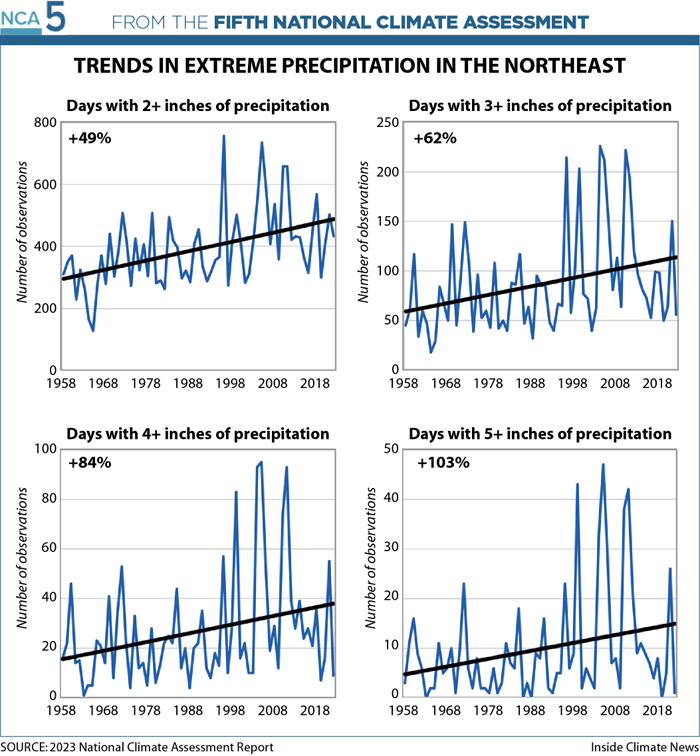
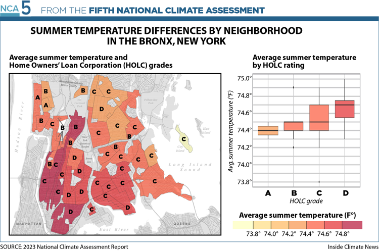
Heat islands in historically redlined areas of the Bronx in New York City, neighborhoods that were once deprived of federal loans and insurance, are now hotter than nearby areas. Communities with lower socioeconomic status and higher percentages of racial and ethnic minorities pay the price in the form of increased heat exposure.
These three examples underscore the three “key messages” of the National Climate Assessment’s Northeast chapter: Extreme weather events are occurring more frequently and having greater impacts, ocean and coastal regions are experiencing unprecedented changes and climate-related hazards, including extreme heat, and are disproportionately impacting low-income communities and communities of color.
Part of the risk is due to aging infrastructure.
“In the Northeast, we have some of the oldest infrastructure in the country and a lot of it obviously faces pretty extreme conditions given the kind of strong seasonality we experience here,” Dave Reidmiller, director of the Gulf of Maine Research Institute’s Climate Center and a co-author of the assessment’s Northeast chapter, said. “So whether that is dams or our electrical grid, or roadways, culverts, wastewater treatment plants, you name it, they all face risks from climate change and the fact that they are aging means that there’s likely to be increased risk to them.”
Other risks come from failing to plan for climate change.
“The development continues, nonstop,” Jack Clarke, the former assistant director of the Massachusetts office of Coastal Zone Management, said of Boston’s Innovation District. “At some point there is going to be a price to pay.”
Many in the Northeast are already paying for the impacts of climate change, but Jessica Whitehead, executive director of Old Dominion University’s Institute for Coastal Adaptation and Resilience and the lead author of the Northeast chapter, said the cost isn’t distributed equally.
“Local level efforts to address climate change, both in reducing greenhouse gas pollution and in adapting and building resilience, are working to improve equity,” Whitehead said. “But the attention to equity in particular throughout the Northeast is still very uneven.”
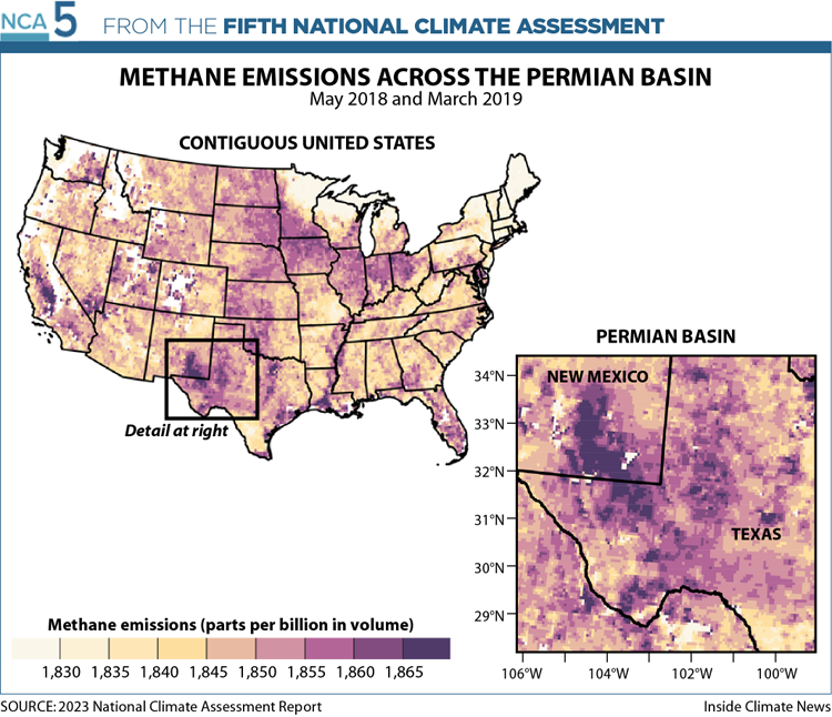
Texas Leads the Nation in Methane Emissions, but Also Excels in Wind and Solar
Opposing forces intermingle in the Southern Great Plains, seat of the nation’s fossil fuel sector as well as its rapidly emerging leader in renewable power generation.
Texas, the U.S. energy capital and the largest Southern Plains state, let off more carbon dioxide than any other state (again) in 2020 (667 million metric tons)—twice as much as the next-highest emitter. Texas also led the nation in emissions of methane (94 million metric tons of CO2 equivalent), much of it leaked from the state’s booming shale oil and gas fields.
The largest of those, the Permian Basin of West Texas and New Mexico, is the nation’s top-producing oilfield. Last year Climate TRACE’s global emissions inventory named it the largest source of greenhouse gas pollution in the world. It leaks enough gas each year to supply seven million Texas households, the National Climate Assessment said.
Meanwhile, robust sectors of wind and solar power generation have exploded in Texas and other Southern Plains states. Since the last National Climate Assessment in 2018, Texas nearly doubled its wind power generation capacity to produce more than any other state. Its solar power generation capacity grew more than five-fold and Texas could soon overtake California as the top solar power producer, too.
The Electric Reliability Council of Texas, the state’s grid operator, expects substantial growth in solar power generation, wind power generation and in battery storage through 2025. Electricity generated from gas and coal, however, is not planned to increase substantially, the National Climate Assessment said.
Agriculture in the Southern Plains will come under increasing pressure from hotter, drier conditions and more frequent or intense drought expected by midcentury in western and southern parts of the region. By 2070, the assessment projects, the Southern Plains will lose cropland as lands transition to pasture or grassland.
In the Northern Great Plains, Unprecedented Extremes and Mental Health Impacts
While the Northern Great Plains do not leap to mind among the states hardest hit by climate change, the National Climate Assessment paints a bleak, even dire, portrait of the region, saying in its summary paragraph that the region is “experiencing unprecedented climate-driven extremes” that threaten key economic sectors and test “the health, well-being, and livelihood” of its residents.
The authors of the data-driven compendium, who note many of their forecasted outcomes with “very high confidence,” do little to sugarcoat their findings in the style of many government documents.
In their discussion of the impact of climate change on mental health, they describe the prominence of “eco-anxiety” among farmers and ranchers and point out that three of the region’s five states (Montana, Nebraska, North Dakota, South Dakota and Wyoming) are among the top 10 in highest suicide rates per capita in the nation. They don’t say which three, but online data from the Centers for Disease Control show that for 2021 it was actually four—Wyoming, Montana, South Dakota and North Dakota, with Wyoming first in the nation and Montana second.
“Suicide rates are particularly high in rural and Indigenous populations, in part because of remoteness from care and the limited number of mental health professionals. Based on geographically broad-based studies, climate change is projected to amplify these risks,” they write.
They also describe an emotional malady called solastalgia—”the distress specifically caused by environmental change while still in a home environment”—and write that it is “most often associated with Indigenous communities, who share collective ancestral ties to the lands and natural resources where they live or previously lived and which are inextricably linked to their identities, cultures, and livelihoods, as well as their physical and spiritual well-being.” The authors add that “solastalgia can also affect others who are connected to the land, such as ranchers and farmers.”
The science presented on the accelerating nature of climate change is equally stark. The number of wildfires across the region’s grasslands increased by 213 percent, from 128 between 1985 and 1995 to 273 between 2005 and 2014. And the number of wildfires and the length of the fire season from the 1970s to the 2000s increased by 889 percent and 85 days, respectively, in the forests of western Montana and Wyoming. Montana has the highest per capita rate of premature deaths attributable to wildfire smoke in the country.
Meanwhile, the largest increases in hail risk anywhere in the nation are taking place in the Northern Great Plains, where southeastern Wyoming and the southwestern part of the Nebraska Panhandle are located in what is called “hail alley.” In the region, hail size, the frequency of large hail events and the length of the hail season, are all projected to increase for the rest of the century, with one research scenario predicting a 302 percent increase in “very large hail days” (defined as having hail two inches or more in diameter) between 2071 and 2100.
Despite the severity of these projected increases and the “unprecedented climate-driven extremes, including severe drought, floods, and wildfires,” the authors also note that several states in the region are failing to link human activities to climate change in their K-12 science curricula.
“Acceptance of the human link to climate change is lower than the national average among adults in the Northern Great Plains region,” they write, “with particularly low acceptance among agricultural producers and agricultural interest groups. This lack of acceptance highlights barriers to collective understanding and climate change response in the region and is matched by a stronger evidence base for actions that emphasize adaptation and resilience rather than mitigation.”
Infrastructure, Agriculture at Risk in the Midwest
The effects of climate change on the Midwest’s agriculture and infrastructure can have significant trickle-down effects on peoples and systems, and its resilience to climate change is critical for livelihood and economic sustainability in the region and beyond.
The Midwest drives a large agricultural economy, with three states in the region—Illinois, Indiana and Iowa—growing a third of the world’s corn and soybeans. “Climate-smart” practices like cover crops could mitigate some of the challenges in crop and animal agriculture posed by rapid swings in extreme wet and dry conditions, snowmelt timing and earlier spring rainfall.
Increasing amounts of rain are causing more intense floods, stressing the region’s infrastructure. The region’s complex system of transportation, movement of goods, energy generation and water infrastructure needs repair and is at greater risk of climate change than some other parts of the country. This is partly due to the infrastructure aging but also because of increasing flood exposure and fluctuating water levels in the region’s rivers and Great Lakes.
“This is the first time the assessment has unpacked the true breadth of what we mean by infrastructure and the true criticality of that infrastructure,” Heidi Roop, director of the University of Minnesota’s Climate Adaptation Partnership and a contributing author of the assessment, told Inside Climate News.
Extreme heat and flooding are also causing costly disruptions in other systems, including ecosystems, emergency management and healthcare. They also pose risks to individual and community health with increased incidence of vector- and waterborne illnesses as well as worsening air quality.
Like in the rest of the country, communities of color are especially vulnerable to the wide-ranging effects of climate change due to systemic and historical biases. However, more research is needed to identify which specific rural and urban communities are disproportionately burdened by the health impacts of climate change and what system solutions could address those disparities, Roop said at a briefing on Wednesday.
Authors at the briefing also recognized that the region has made strides in investing in farming, infrastructure and emergency management to adapt and mitigate climate change impacts, but they said more is needed.
Southwest Grapples With Drier, Hotter Climate, Collaborates on Water Issues
The slow-moving ecosystems of the Southwest face rapid climate change–induced transformation, forcing communities to reckon with a cascade of risks as temperatures rise and the region undergoes aridification, with the impacts of climate change becoming “increasingly apparent and widespread” over the last five years, the report’s authors wrote.
The NCA makes one thing clear: Nearly every problem the Southwest faces, from the region’s rising temperatures to drought to wildfires to rising sea levels along the coast, is interconnected.
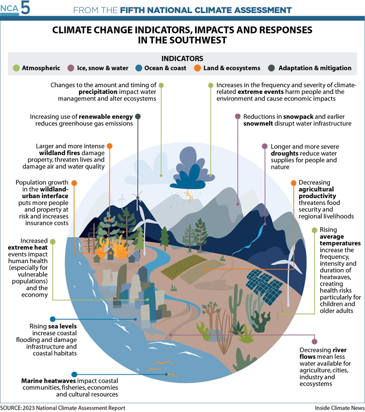
Hotter temperatures caused by climate change are leading to record-low precipitation and making the atmosphere thirstier; water from soil and plants is being sucked up into the atmosphere via evapotranspiration. That’s led to reduced runoff in the Colorado River Basin and elsewhere even in wet years, affecting agricultural production. Those dryer soils, combined with long-standing policies of “fire suppression, widespread logging and livestock grazing, and elimination of Indigenous fire use,” have made wildfires bigger and deadlier than ever before.
“Our scientific understanding of climate impacts on these sectors has improved to the point where we’re now able to understand how the risks can cascade and how risks from one sector can translate into risks in other sectors,” said Dave White, the director of the Global Institute of Sustainability and Innovation at Arizona State University and a lead author of the chapter.
The region, like much of the country, is now transitioning away from planning for climate change to implementing solutions to address it, the chapter’s authors said, highlighting collaboration along the Colorado River Basin to address shortages in the system.
“We’re moving from incremental adaptation to transformative adaptation, from something that kind of just tides us over to something that really seeps through all these interconnections in our systems to deal with climate change,” said Elizabeth Koebele, an associate professor of political science at the University of Nevada, Reno and co-author of the chapter.
Hellish Consequences in Hawaii, Dizzying Pace of Warming in Alaska
The nation’s two non-contiguous states have unique climate vulnerabilities, and in separate chapters on Alaska and Hawaii, the NCA explored how their risks are amplified due to isolation from the mainland, the struggles of their Indigenous peoples, and their deep reliance on a profoundly changing Pacific Ocean.
Together, the two states—one on the Arctic Circle and the other in the tropics—illustrate how warming is disrupting life across the full spectrum of climate conditions.
Colder regions like Alaska will see some benefits, the report authors say, but the longer growing season and potential for more locally-grown food will be accompanied by increased pests, flooding and ground collapse from thawing permafrost. On the warm Hawaiian islands, the surrounding seas offer scant protection against droughts that are increasing in frequency, severity, and duration—with potential hellish consequences for the vacation paradise.
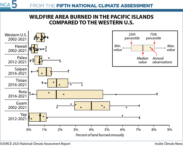
The wind-driven brush fires that exploded across drought-stricken Maui in early August—with 97 fatalities, the deadliest U.S. wildfire in more than 100 years—happened too recently to be included in the NCA. But even in the draft version of the report one year ago, the authors warned of increasing fire risk in Hawaii and the other U.S.-affiliated Pacific islands like Guam and Saipan, which they considered as a group. A greater percentage of land area is burned each year on these islands than in the western continental United States, and a proliferation of fire-prone and water-guzzling invasive species is increasing the risks.
Meanwhile, the oceans that have been the backbone of Hawaii’s economy are now a threat. As soon as 2100, if emissions follow a medium trajectory, 3.2 feet of sea level rise above 2000 levels is expected, putting at risk 550 cultural sites, 38 miles of coastal road, 6,500 structures and potentially displacing 20,000 residents, the report says.
Alaska’s largest revenue-producing industry, oil and gas, is being transformed by climate change in multiple ways. Companies now must make intensive efforts to keep the ground cold and solid to support roads, pipelines and buildings. And as operations become more costly, the industry’s future becomes more uncertain. The NCA said diversification of Alaska’s economy is key to a resilient future.
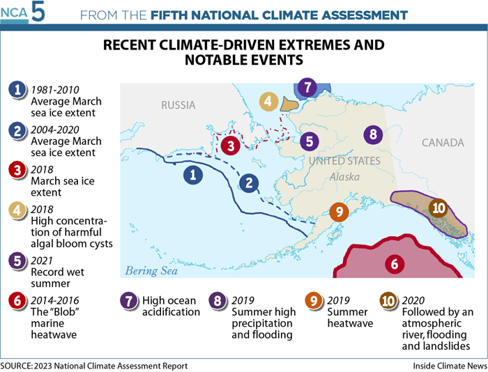
Because of its high latitude, Alaska is warming up to 2.6 times faster than the Lower 48 states, triggering a dizzying array of impacts. Just since the last NCA was published in 2018, the state has seen record low sea ice, the world’s highest rates of ocean acidification, and an atmospheric river in 2020 that broke all-time extreme 24-hour precipitation records.
Daily temperatures in southern and interior Alaska spiked to more than 20 degrees F above normal in a 2019 summer heatwave, blowing away predictions made in the last NCA. The climate assessment released during the Trump administration said that by the end of the century, even if emissions follow a high trajectory, the highest anticipated temperature would be 4 to 8 degrees F above normal. The new NCA projects the state’s average surface temperature rise in a high-emissions scenario would be 14.2 degrees F (7.9 degrees C.)
Climate-related food supply chain disruptions are an especially dire threat in states, like Alaska, where residents already pay high prices because of reliance on imports from the mainland and elsewhere.
Especially vulnerable are members of the 21 distinct Indigenous peoples who make up one-fifth of the population of Alaska. King salmon contributes 64 percent of all protein to rural Yukon River communities, but since 2020, the river’s subsistence fishery has been closed for the first time ever, with no foreseeable plan to reopen. High water temperatures are believed to have contributed to the fishery’s collapse. The situation is “disastrous to Indigenous peoples’ physical, mental, cultural, and spiritual well-being,” the NCA authors wrote.
The NCA sees efforts to apply Indigenous knowledge—for example, reviving traditional farming, fishing and land-management practices—as a hopeful trend that could help build more resilient water and food systems. “Restoring Indigenous agroecology practices can support conservation, food security, and broader socio-cultural objectives in the face of shifting precipitation and [sea level rise]” in Hawaii and the Pacific Islands, the authors say.
Caribbean Faces “Permanent Inundation”
Out of all the U.S. states and territories, perhaps none exemplify the ugly consequences of climate change more than Puerto Rico.
The United States’ largest territory received special attention in the Fifth National Climate Assessment. The latest iteration of the report, which was published Tuesday, dedicated a full chapter to the Caribbean region, which climate scientists have warned is especially vulnerable to the effects of global warming.
“In coastal areas, sea level rise threatens permanent inundation of infrastructure, including roadways, railways, ports, tunnels and bridges; water treatment facilities and power plants; and hospitals, schools and military bases,” the congressionally mandated report said. “More intense storms also disrupt critical services like access to medical care, as seen after Hurricanes Irma and Maria in the U.S. Virgin Islands and Puerto Rico.”
In 2017, Maria swept through Puerto Rico with Category 4 winds that heavily damaged the island’s electrical grid and plunged nearly every resident’s home into darkness for days, with some areas going almost a year without power. Researchers would later estimate that nearly 3,000 people died either directly or indirectly because of Maria.
Last year, nearly half of the homes in Puerto Rico lost power again after Hurricane Fiona dumped a record amount of rain on the island, undoing years of progress as flash floods toppled transmission lines and other recently installed infrastructure, including a temporary steel bridge that was meant to last for decades. Islands like Puerto Rico will only see worse flooding, climate scientists say, as sea levels rise and powerful Atlantic storms become more common.
The blackouts have now become so widespread and frequent in Puerto Rico that federal agencies have dedicated more than $20 billion in aid to help repair the tattered grid and other basic infrastructure on the island.
When it’s not harsh winds and floodwaters, it’s the heat. Puerto Rico has also seen a big uptick in severe summer heat waves in recent years, said Ruth Santiago, a co-author of Tuesday’s report and a resident of the island’s southern coastal city of Salinas. “We saw that just this year,” she said. “Starting in about April and May, we had a record-breaking heat wave for about six months.”
Keep Environmental Journalism Alive
ICN provides award-winning climate coverage free of charge and advertising. We rely on donations from readers like you to keep going.
Donate NowIn June, areas of Puerto Rico got so hot—reaching a deadly 125 degrees Fahrenheit on the heat index—that it astonished some meteorologists who were watching the situation unfold.
Santiago, an environmental attorney who also sits on the White House Environmental Justice Advisory Council, said she was happy to see that the final version of the National Climate Assessment, which undergoes rigorous vetting by hundreds of experts from both the federal government and the private sector, retained all the key points that she and her co-author working group wanted to make about the reality of climate change in the Caribbean.
One was that most Puerto Ricans want to transition from a centralized fossil fuel-based power grid to a decentralized one powered predominantly by rooftop solar systems. The devastation of Maria compelled broad consensus among the island’s residents that clean energy paired with microgrids—a combination many energy experts say can better withstand extreme weather conditions—is the future for Puerto Rico. And in 2019, the territory passed a law requiring 100 percent clean energy by 2050.
But Puerto Rico is struggling to add enough renewable energy capacity to keep it in line with its climate law’s mandatory targets, frustrating local residents like Santiago who have worked tirelessly in recent years to get elected officials to act more urgently.
Tuesday’s report reflected that frustration, Santiago said. “This really large group of experts basically coincided with what our working group put forward in terms of decentralization—not just the decarbonization—of the electric system,” she said, and they noted community efforts to move “toward distributed renewable energy like rooftop solar.”